Hiking
Photos
About Millard Canyon
|
|
|
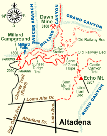
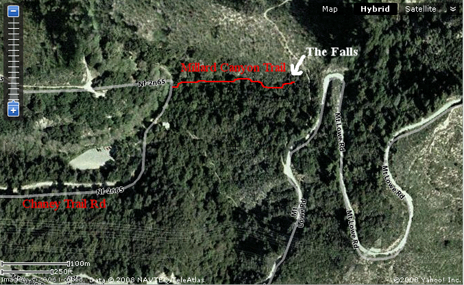
Overview The short Millard Canyon Trail leads up a tree-shaded canyon one-half mile to a 50' waterfall. The trail is a special delight for small children, since it is an easy hike in a cool, shady canyon alongside a stream with regular flowing water, that has a definite end at a pretty waterfall. Thus there is no problem with small children wanting to go farther along the trail than their capabilities allow. (Tom has even taken a leashed cat along the trail in the distant past.) There is a variety of entertaining small animals in or near the stream--a mini-course on aquatic ecology! With the added bonus of boulders to play on along the way, what more could a small child (or adult!) desire? Locally, Millard is pronounced "mih LARD'" with the accent on the second syllable. Lincoln Avenue Water Company owns the water rights to Millard Canyon, and takes water from the canyon above the falls, diminishing their flow. The anecdotal knowledge we have obtained is that they take about 7 cubic feet of water per second, which was not changed after the new homes in La Viña were built. (They acquired water rights farther downstream in return for supplying water to those homes.) Maps: Pasadena USGS Quadrangle. Season: All. Best weekdays to avoid weekend crowds. Trailhead and directions to trailhead: From Loma Alta Drive in Altadena, go north on Chaney Trail to the top of Sunset Ridge turning left and going down the hill on the other side to a large parking lot. An Adventure Pass is needed. Walk past the campground. The trail, FS 12W18, begins this side of the stream crossing. Be aware that entrance and exit along Chaney Trail (Road) is between the hours of 6 am and 10 pm only. There are two horse tie-ups in the Campground itself. Length: The trail itself is 0.5 miles long from the end of the campground to the waterfalls, and it is a quarter mile from the parking lot through the campground to where the trail begins. Thus the roundtrip hike from the car is 1.5 miles. (Robinson's "1 mile" is for the trail itself.) Tom's pedometer agreed closely with the 1.5 mile distance. "Topo!" gives 0.18 mile from the parking lot to the trailhead, compared to 0.25 miles, and only 0.27 mile for the distance along the canyon, compared to 0.50 mile, which doesn't take into account the twists and turns of the actual trail. Elevation Changes: The elevation of the parking lot is ~1800'. The trailhead is at ~1880' and the falls itself is around 1960'. Since there is no up and down along the trail, the total elevation gain is close to the 150' given by Robinson. Trail Condition: Although the trail looks like it is almost all big boulders and sandy-bottomed stream, there is nearly always a good level trail to follow. There are ~4 exceptions where one must step up 1-2' on large rocks, easily negotiated even by children. Also, a useful staircase of rocks enclosed in wire has been built at the beginning to get over a debris dam. Due to these steps, and narrow width in places, wheelchairs could not negotiate this short trail. The main trail is obvious at all times, although there are a few alternate trails that either quickly peter out or rejoin the main trail. Trail Maintenance: Somebody has been taking care of this place! We thank them wholeheartedly. Earlier hike descriptions tell of the litter and debris of crowded weekends. It was impressively clean on 4/11/00 and 4/25/00. What a pleasure to hike a foothill canyon and not come across graffiti and garbage! The bathroom still smells awful, however. History: Millard Canyon was originally called Church Canyon because timber for the Old Plaza Church in Los Angeles was cut in the upper part of Millard Canyon above the Falls. (Robinson, The San Gabriels, pp. 10, 11, 12.) Millard Canyon acquired its current name from Henry W. Millard, who homesteaded it with his family in 1862, raised bees there and hauled timber to Los Angeles. He moved to the Downey area about 1872, leaving a rustic cabin and two graves. (Ibid. p. 29.) Take the road from the east end of the parking lot through the campground. At the end of the campground you'll see the water flowing over the road. This water has just enjoyed a 50' fall over the waterfall about 15 minutes earlier, assuming the water flows at 2 mph. Just before the water is the signed trail to your right. You cross over the debris dam using steps made out of caged rocks, and then easily follow the main trail up the canyon. Immediately on your left is what looks like a door to an old mine, just off the trail. The canyon is heavily shaded, but eupatory provides a colorful show in springtime with its masses of white blossoms. There is very little poison oak, if any, in the area of the trail. During low water, most of the time except after storms, the water disappears from the stream bed between 0.05 and 0.10 mile from the falls. This allows you to better hear the waterfall before you see it. Ask your children to speculate about what happens to the water in this stretch! (The water disappears into the sand and gravel deposited just below the falls, and reemerges downstream when the amount of sand and gravel becomes insufficient to hold all the water.) The falls themselves are delightful, with a small pool at their base. The gentle trickle of water most of the time makes it pleasant to stay for a while without roaring in your ears. You can study the three rocks at the top of the falls that have been caught in the process of falling down the falls, and speculate how much longer they will last. People have been injured trying to climb the falls, so please don't attempt to do so. There is a very easy way to get to the top of the falls, but not from this trail. Take the Sunset Ridge Trail to its trail junction just above Millard Falls, a few tenths of a mile from the trailhead. The left branch goes past an old cabin down the canyon into the streambed. At the streambed, a left takes you to the top of the falls within a quarter mile. (A right turn takes you to Dawn Mine.) Info taken from http://tchester.org/sgm/trails/millard.html |
|
| Maps & Things
|
|
 |
|
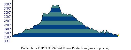 Millard Canyon - Dawn Mine Elevation Profile |